 |
Click to enlarge |
|
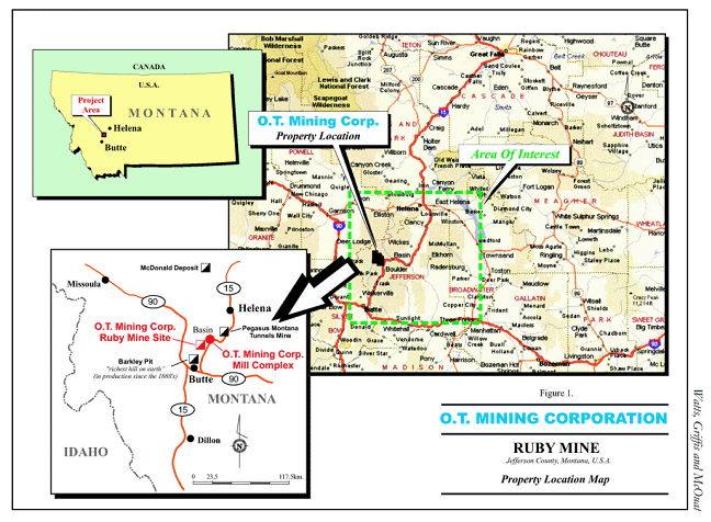
Given the geological provenance of the O.T.Mining Corporation’s Ruby Property, a parallel can be drawn with the famous Butte Mining District some 14 miles to the south. From 1880 to 1964, the Butte Camp produced some 327 million tons of zinc, lead, copper, gold, silver and manganese ore from underground operations which exceeded depths of over 5000 feet. Furthermore, from 1955 to 1982 some 1.5 billion tons of additional ore were mined from the adjacent Berkeley open pit. Butte was called “The Richest Hill On Earth,” and was exceeded only by the South African Witwatersrand gold deposits in metallic wealth extracted.
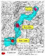
The Montana Tunnels Mine located some 20 miles north-east of the Ruby Mine has produced approximately 1 million troy ounces of gold, 11 million troy ounces of silver and in excess of 100,000 tons of lead and 300,000 tons of zinc.
An earlier flown regional airborne magnetometer survey detected a pronounced magnetic low over the Butte deposit, the Montana Tunnels deposit as well as on the Ruby property. Such a magnetic low is indicative of large-scale rock alteration, which in many cases provides the host environment for the deposition of major ore bodies.
Subsequently, cutting edge geophysical and geochemical technologies were employed by O.T. Mining on the Ruby property. These surveys included helicopter-borne magnetic and electromagnetic surveys (Fugro, 2001), Titan 24 “Deep-Looking” induced polarization (“I.P.”; Quantec, 2004) and detailed ground I.P. (Matrix Geotechnologies, 2005, 2006) as well as Mobile Metal Ions (“MMI”) soil geochemistry. Results confirmed the presence of extensive zones of sulphide mineralization and related alteration of the host rocks. The results were interpreted to be indicative of possible ore deposits.
Follow-up on these targets areas was based upon geological mapping and sampling and the widespread application of the innovative MMI soil geochemical technology. The MMI surveys have the unique capacity of being able to detect mineralization that occurs directly beneath the sampling point at depths exceeding 1000 feet. As well, it can identify individual metals present in soil that originated from a base metal (copper, lead, zinc, nickel) or precious metal (gold, silver, platinum, palladium) target that is characterized by a unique airborne or ground geophysical anomaly.
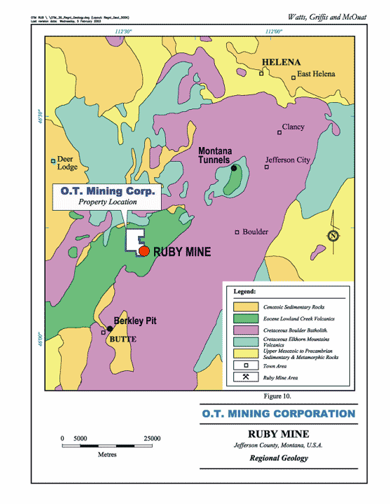
The Butte ores were hosted by a series of granitic intrusions, referred to as the Boulder Batholith. The Ruby property, however, is covered by younger volcanic rocks so there is no exposure of the Batholith. These younger rocks, the Lowland Creek volcanics, however, do host the very high-grade Ruby and Kit Carson deposits, which may or may not be geologically related to the postulated mineralization in the batholitic basement rocks.
Extensive areas of the volcanics exhibit hydrothermal alteration, which can be a favorable host for ore mineralization. Since the volcanics are much younger than the Boulder Batholith, it means that there must be an intrusive, younger than the volcanics, which caused the extensive alteration. Based on interpretation of the airborne magnetic low and the depositional sequence of the volcanics, it can be surmised that the alteration exists not only in the volcanics but also in the underlying basement Batholith.
Further interpretation of the many anomalies detected during the geophysical, geochemical and geological investigations, strongly indicate that there could be a replica of Butte type mineralization, associated with the deep seated alteration in the Boulder Batholith underlying the upper Lowland Creek volcanic formations.
We do not know whether the youngest intrusion carried mineralization, but do know that it provided the heat, which helped pervade the volcanics with hydrothermal fluids, which in turn created favorable hosts for mineralization. The source of this mineralization could have been derived from mineral laden meteoric waters trapped in porous volcanic ash layers, which were subject to retrograde boiling and ascended upwards through fractures induced by the intrusion. Precipitation of the contained metals was caused by a drop in temperature and pressure in the ascending fluids.
MMI surveys have confirmed that there is strong coincidence between metal content, airborne magnetic lows and the hydrothermal alteration. We know that the Butte ores were associated with the hydrothermal alteration of the Boulder Batholith. Interpretation of the airborne survey shows that at depth below the bottom of the Lowland Creek volcanics there appears to be an extensive alteration zone, which must correspond with the top of the Boulder Batholith. MMI has been proven to have the capacity to detect mineralization to depths of at least 2000 feet. In all probability some of the MMI responses are due to favorable mineralization within the Lowland Creek volcanic rocks, but as well, some of these signals may emanate from the Boulder Batholith. This combination provides a compelling case for deep drilling.
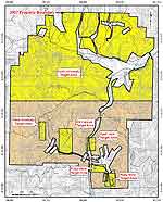
The documentation of a large and intense magnetic low centered on the Ruby property based on the Fugro (2001) airborne geophysical survey stimulated MMI soil geochemical surveys and geophysical surveys property-wide. The application of MMI Technology in 2002 resulted in the definition of an approximate 400 square foot copper, zinc and cobalt soil geochemical anomaly in an area of the property known as the North Anomaly. The O.T. Mining Corporation tested this anomaly with vertical drill hole NA04-6 in 2004. Below 600 feet the drill hole intersected a zone of potassic- and phyllic-altered quartz monzonite of the Boulder Batholith, host rocks to the Richest Hill On Earth at Butte.
This zone persisted for approximately 2,600 feet vertically and comprised a continuous zone of disseminated and veinlet chalcopyrite with molybdenite and pyrite. This new discovery heralded the realization of significant potential for the Ruby property to host “Butte-type” base and precious metal ore bodies.The details of the surveys undertaken subsequent to this discovery follow below and build the strong case for the presence of world-class ore bodies to exist on the property.
|